A Better Understanding of Coral Reef Ecosystems

Pelagic predators such as these barracuda, Sphyraena qenie, are part of the coral reef ecosystem in the U.S. Line Islands (NOAA Photo by Kevin Lino).
A team of scientists have embarked from Hawai'i on a three-month survey of coral reef ecosystems at Johnston Atoll, the U.S. Phoenix Islands, the islands of American Samoa, and the U.S. Line Islands in the tropical Pacific Ocean. The overarching objective is to better understand the coral reef ecosystems of these areas, many of which are seldom explored. The research expedition is part of a regular monitoring program, conducted by the Coral Reef Ecosystem Division (CRED), headquartered in Honolulu, Hawai'i. The expedition is supported by NOAA's Coral Reef Conservation Program and involves extensive cooperation among NOAA scientists and research partners, including the University of Hawaii Joint Institute for Marine and Atmospheric Research (JIMAR), the U.S. Fish and Wildlife Service, San Diego State University, and the Papahānaumaokuākea Marine National Monument.

The research expedition will be carried out from February 27 to May 24, 2012 aboard the NOAA ship Hi'ialakai. Under the leadership of Chief Scientists Dr. Jill Zamzow, Dr. Bernardo Vargas-Angél, and Jamison Gove, a diverse team of researchers will be conducting multidisciplinary coral reef ecosystem surveys, assessing the status of fishes, corals, algae, marine invertebrates, and the oceanographic conditions in which these organisms exist. The scientific data collected during the three-month research expedition will enable informed and effective implementation of ecosystem-based management and conservation strategies for coral reef ecosystems, helping to ensure their protection for generations to come.

Saturday, February 27, 2010

Cool Critters of the Reef

text and photographs by Erin Looney

One of the many benefits of conducting coral reef research is the cool critters we encounter almost every day. Whether it is something big, such as a shark, turtle or dolphin, or something small, such as a nudibranch, sea anemone or crinoid, these creatures are all amazing in their own way. Here are a few examples of what we're seeing. All of these organisms were seen in a reef environment between 10 and 20 meters (30 - 60 feet) deep. Enjoy!

Trapezia rufopunctata, Trapezid Crab

Amphiprion perideraion, Pink Anemonefish

Tridacna maxima, Giant Clam

Plerogyra sinuosa, Bubble Coral

Friday, February 26, 2010

A Visitor at Dawn

by Cristi Richards
Flying Fox seen over Cockscomb, Tutuila (photograph by Benjamin Richards)
Preparations for each day of diving generally begin before sunrise, when a quiet, sleepy hush still envelopes the ship. This seemed especially appropriate when yesterday morning, just before sunrise, a silent, graceful silhouette was observed gliding behind the ship. It wasn't a bird but a flying fox or fruit bat.

There are three species of bats living in Samoa, two large fruit-eating bats and a smaller insect-eating bat, which are the only three native mammals in the Samoan Islands. These can seem odd to visitors coming from places where bats are small and generally hard to find or see. In Samoa the sight of a flying fox is a common occurrence. The bat following the ship this morning was one of the fruit-eating varieties which can attain up to a 3 foot wingspan and making it either a Pteropus samoensis (Samoan Flying Fox) or a Pteropus tonganus (Tongan Fruit Bat). While most bats are nocturnal, these bats can be seen throughout the day soaring on thermals or moving between roosting and feeding sites during the dawn and dusk hours.

Both species of bat consume a variety of foods including nectar, pollen, sap and the juice of fruits and leaves. Eating only the juice, the bat will chew on the fruit and press the pulp against the roof of it's mouth creating a pellet of dry pulp known as an ejecta. The ejecta is then spit out to make room for more pulp. This process makes it easy to determine where bats have been feeding and by analyzing the ejecta (commonly found on the hood of your car if you happen to park under a breadfruit tree).

The fruit bats found in Samoa also play an important role in pollination and seed dispersal, increasing the productivity of fruit trees transporting seeds to cleared areas. This aids the natural reforestation process. We are not sure how our flying fox visitor came to be sailing behind the Hi'ialakai instead of feasting in a breadfruit tree, but it was an impressive sight that caught the attention of everyone awake at that hour.

References:
Natural History Guide to American Samoa, 3rd edition, 2009. P. Craig, editor

Thursday, February 25, 2010

Notes from a Coral Reef Microbiologist

Collecting water samples

by Tracey McDole
Imagine that you are a scientist diving on a coral reef… what types of organisms would you choose to study? Many different life forms probably come to mind, including fish, invertebrates, and of course the corals. However, these are all macroorganisms (“macro” meaning large). In other words, these are organisms that can be seen with the naked eye. What you may not realize, is that an incredible diversity of life also exists at the microscopic scale. In fact, in one drop of seawater there are on average 1,000,000 individual bacterial cells! If that figure isn’t amazing then try one billion viruses per drop! That means that in just a few milliliters of seawater there are more viruses than there are humans on planet earth! Don’t worry, most of them are bacteriophages, viruses that only infect bacteria.

There are, however, some marine viruses that cause disease in reef macroorganisms. Did you know that corals get tumors, a growth anomaly that may be caused by viruses in the family Herpesviridae? Don’t get me wrong, in a healthy reef ecosystem, viruses and microbes play beneficial roles. The coral reef food web is structured so that energy and materials flow from the microbes to macrobes, and back again. Therefore, both viral and bacterial communities are essential components of any healthy reef system.

One of the biggest and most pressing questions that coral reef scientists are currently trying to understand is: How do the combined effects of pollution, overfishing, and climate change result in degraded coral reefs? One way to start is to determine if both groups of organisms (macrobes and microbes) function and interact differently on healthy versus degraded reef systems.

To answer this bigger question, we must start by asking relatively simple questions. How many bacteria and viruses are there on a healthy versus a degraded reef? Are the types of microbes and viruses inhabiting the water column above a healthy reef different from those inhabiting a degraded reef? The first question involves capturing the bacteria and viruses on a filter, staining the filter with a fluorescent-dye that binds to DNA, and finally visualizing the filter with a fluorescent light microscope. The result looks like the night sky! Luckily the microbes and viruses are counted by a computer program.

Microorganisms vs. Macroorganisms
So who’s there? Good guys or bad guys? Answering this question involves a technique called DNA sequencing. DNA from inside the viruses and bacterial cells is purified and the genetic material can then be replicated. When there are enough copies of the DNA, a machine literally reads the base pairs in the DNA sequence. If the DNA sequences match a known sequence in a master database, the microbe or virus that it came from can be identified. Typically, only a portion of the sequences actually “hit” something in the database. This means that the majority of microorganisms and their genes are still waiting to be discovered. But with each water sample we get closer to understanding this complex web of microscopic interactions on the reef.

Wednesday, February 24, 2010

Lilies of the Sea

Crinoid or Sea Lily from American Samoa (photograph by Cristi Richards)
by Benjamin L. Richards

Today the benthic team recovered three Autonomous Reef Monitoring Structures (ARMS) which have been attached to the seafloor in Fagatele Bay National Marine Sanctuary, American Samoa, for the past two years.  This smallest and most remote of all the National Marine Sanctuaries is also the only true tropical reef in the National Marine Sanctuary Program.  Fagatele Bay, on the southwestern coast of the island of Tutuila is a small eroded volcanic crater which provides shelter for a wide variety of organisms that thrive in its protected waters.

After locating the dive site, we slipped over the side of the boat into crystal clear waters and descended to a sea floor covered in coral. We located the three ARMS easily and, after installing a new set of ARMS and a set of calcification plates which will be used to investigate the impacts of ocean acidification, we removed the old ARMS and brought them to the surface.

After returning to the ship, we spent several hours disassembling the ARMS and sorting through all the various creatures who had made it their home.  The biodiversity was amazing. We found a host of crabs, snails, shrimps and a myriad of other tiny and amazing creatures.  We also found our first crinoid.

Crinoids, or sea lilies, are echinoderms (relatives of sea stars and sea urchins) and have lived in the tropical oceans since at least the Ordovician period (~450 million years ago).  Like sea stars and urchins, most crinoids are free swimming and feed by filtering small particles from the passing water with their feathery arms.  Once the food is trapped by a sticky mucus on the tube feet, it is moved towards the mouth at the center of the body.  It has been found that crinoids living in environments with a relatively low abundance of plankton have longer arms than those living in plankton-rich waters.  This is presumably to increase the surface area where food can be trapped.

Finding a such a beautiful and delicate creature in the ARMS was exciting for members of the ARMS team as well as for those who stopped by the lab to glimpse the latest arrivals from the reef.  The diversity of cryptic invertebrates being found is an exciting testimony to how much more there is to learn about reef ecosystems.  As part of the Census of Coral Reef Ecosystems (CReefs) project of the Census of Marine Life, CRED is collaborating with international partners to deploy ARMS on coral reefs around the globe to establish biodiversity baselines and monitor changes over time.

Sunday, February 21, 2010

Talofa Tutuila

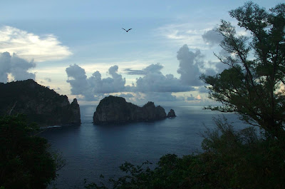
Aunu'u and Tutuila (left to right), photo taken by PIBHMC
By Kerry Grimshaw

After nearly a month into our cruise we have begun our work in the US Territory of American Samoa. We are conducting surveys around the island of Tutuila which is the largest and most populated of all the islands in the Territory. Tutuila has a land area of 141.81 km2(54.75 mi2) which is just slightly smaller than Washington D.C. As the third largest island in the Samoan Archipelago (Savaii & 'Upolu in Samoa are 1 & 2 respectively) it is distinctive in the South Pacific for having a large deep natural harbor.

As one of the most protected harbors in the South Pacific, Pago Pago became a point of contention when the United States gained exclusive use in 1872. However, both the British and Germans also had political and trade interests in Pago Pago. After about a decade of mounting tensions and a serendipitous cyclone, the 3countries negotiated in 1889 where Western (Independent) Samoa was ceded to the Germans, eastern Samoa went to the Americans, and the British were happy with German renunciation of Tonga, the Solomon Islands and Niue.

In April of 1900 eastern Samoa was formally annexed by the USA. Traditional rights were protected in exchange for a military base and a coaling station; however, Samoans became US Nationals, but not US citizens. Pago Pago became instrumental during World War II as the center of the Samoan Defense Group, which was the largest of the Pacific Defense Groups. As the war moved north and west, American Samoa became a strategic backwater. In the postwar era, American Samoa's military importance declined and in 1951, the Territory was transferred to the Department of the Interior, under whose jurisdiction it remains.

Until the 1960’s, American Samoa remained almost entirely traditional. After the modernization era, the subtle and restrained US presence was over. In 1977 the first elections were held for democratically elected leadership, replacing the leadership of appointed governors.

Pago Pago Harbor
Tutuila has a reef area of 36.2 km2 (14 mi2) and is home to more than 140 species of corals. Tutuila's waters are protected by the 0.7 km2 (0.3mi2) Fagatele Bay National Marine Sanctuary, as well as by the National Park of American Samoa, which covers the north-central part of the island and approximately 5 km(1.9 mi2) of coastline. Tutuila is also unique because of its extensive banks that occur 1-9 km (0.6-6 mi) offshore. On these banks CRED has conducted camera surveys in previous years and documented the presence of corals and numerous species of fish.

We’ll be working in the waters surrounding Tutuila until March 2nd when we begin our transit to Swains Island. For those of you reading from the island of Tutuila you may see us as you are out and about during this time.

Thursday, February 18, 2010

Corals, corals, everywhere ...

by Bernardo Vargas-Angel


High percent coral cover and species diversity; that is what we encountered while working site TUT-09, located on the south-facing shores of Tutuila Island. It was a vibrant tapestry of texture and color; Montipora, Acropora, Pocillopora, Hydnophora, Coscinaraea, Leptastrea, Leptoria, etc; the list of coral genera was endless, and so was the number of individual colonies encrusting on the flat bottom.

The coral working-group of the Benthic Rapid Ecological Assessment (REA) team specializes in gathering data that pertains to the structural demographics of the coral populations. In other words we are interested in acquiring information about the different types of corals present on the reef, their relative abundance, as well as the sizes of the different colonies. Once collected, this information is later summarized and analyzed, and is made available to local, regional, and state resource managers.  Armed with this information, these managers can make informed decisions pertaining to the administration and use of natural resources around the island.

The coral working-group collects the coral demographic data along two belt-transects, 25m in length by 1m width. Today, my dive buddy Erin and I were particularly challenged in getting our work accomplished at survey site TUT-09, not only due to the high numbers of coral colonies growing on the bottom, but also because we had wave and surge action which made it difficult stay focused on one portion of the bottom at a time. Nonetheless, after a long 85 minute dive, Erin and I emerged satisfied with the work we accomplished, and were pleased to have had the opportunity to investigate such a site.

Wednesday, February 17, 2010

Visiting the Hi'ialakai

by Cristi Richards

On February 15, the NOAA Ship Hi’ialakai opened its doors and gangway to the American Samoa community in Pago Pago for an open house. Members of the public were invited to tour the ship and hear about all aspects of its operations from the Bridge to the Fantail. Participants were treated to a Bridge familiarization with an explanation of the electronics and maneuvering procedures, an overview of the deck machinery and how the small boats are launched for daily operations and hands-on demonstrations of the scientific aspects of the cruise including algal identification, the morphology of coral disease, fish survey techniques, towboard operations, and ARMS and invertebrate observations via a microscope. Crew and Scientists participating included ENS David Vejar, SS Gautano Maurizio, Chief Scientist Benjamin Richards, Oceanographer Oliver Vetter, Benthic Team members Molly Timmers, Cristi Richards, and Bernardo Vargas-Angel, Towboarders Kevin Lino, Jason Helyer, and Fish Team member Paula Ayotte.

Despite the rain and President’s Day, we had a modest turn out and were excited to see members of the public interested in what we spend so much time working on. It was especially wonderful to see the curiosity on children’s faces when learning about what they probably see every weekend on the beach. One set of children were particularly surprised when shown a slightly green, calcified, crunchy and segmented example from the local beach which is actually the green alga Halimeda. This alga is one of the primary sand producers in the area and a common sight on local beaches however many people might not identify it as a plant. The Towboard demonstration was also a highlight as the team had recent video footage from Howland and Baker Islands playing. The Towboard methods allow a large area to be covered and the footage gives the viewer the sense of flying over the reef. We are always excited to show off the ship and the work that we do. We are looking forward to the next import when we can again invite members of the public aboard what we’ll be calling home for the next 2 months.

Friday, February 12, 2010

Finding the lee

by Benjamin Richards
Hurricane Rene tracks across Samoa
Our transit south from Baker Island to American Samoa has gone well and has been largely uneventful.  That is, at least, until we began to feel the effects of hurricane Rene, which has been wandering around in the south Pacific.  The storm first tracked east to the north of Samoa and then turned back to the west, this time to the south of Samoa.  As Pago Pago, our intended destination is on the south side of the island of Tutuila, this southerly storm track did not bode well.  Waiting to see how conditions would change, we slowed our southward course and eventually decided to delay our arrival in Pago Pago, to ride out the storm in the lee of the island of 'Upolu.

During our transit this morning we experienced stiff winds in the neighborhood of 40 knots and driving rain, but the good ship Hi'ialakai rode the seas well and handled beautifully.  We are currently in the lee of 'Upolu, where the wind and seas are calm and a gentle swell rolls in from the east.  We will bide our time here until the storm clears and plan to arrive in Pago Pago on the morning of 2/14, Valentine's Day.

Wednesday, February 10, 2010

Coral Species Diversity and Conservation Challenge in the U.S. Pacific Ocean

by Jim Maragos, Ph.D.,Coral Reef Biologist, U.S. Fish and Wildlife Service, Honolulu & Member, Coral Specialist Group, Species Survival Commission, IUCN
photographs by Russell Moffitt


The Pacific Ocean supports the largest and among the oldest habitat for coral reefs, and the United States now manages the largest array of protected coral reefs in the world. Especially during the past century, coral reefs have been increasingly threatened by the activities of mankind, but now population growth, unmanaged fishing, and climate change will pose as more severe threats to coral reefs during the next century. Stony corals and coralline algae are the main life forms responsible for the biogenic growth and maintenance of reefs worldwide, yet we are only now focusing attention of the status of threats to these principal reef builders. Most reef corals consist of thin living animal tissues over a stony skeleton, and most are colonial and dependent upon single celled plants (called zooxanthellae) that live in their tissues for growth and nutrition. As such, these factors complicate efforts to define coral species and determining which are under threat and warrant special protection.

Scientific description of corals began with Linnaeus in 1758, and for most of the following century, definition of coral species relied on dead skeletons, written descriptions, and sketches. Although this approach has been successful for higher non-colonial animals such as birds, mammals and reptiles, corals altogether lack the prominent diagnostic features of these species such as eyes, noses, beaks, limbs, heads, tails, ears, faces, consistent coloration, etc. Moreover, the English language has mostly evolved in regions lacking corals, requiring Latin derived words as the basis for describing them, further confounding the understanding of the terms by which corals are separated into different species. Since 1850, photographs accompanied the published description of coral species, but virtually all of these were of the dead, cleaned skeleton of corals, with description of living tissues still relying on artistic sketches and written descriptions. As a consequence there were many more coral species described than what actually occurred in nature due to the lack of sufficient information to distinguish them.

Over the past several decades, scuba diving and guide books with colored photographs of living corals have helped many scientists learn coral species underwater where they live. Nevertheless, the colonial nature of living coral allows many to change their growth form to better adapt to differing habitats, and there are still concerns over which coral descriptions are the real species and which are “junior synonyms” of them. Over the past half century coral taxonomists have grappled over alternative means to describe individual species including numerical taxonomy of morphological features and immunoassay techniques to distinguish closely related species. However, these have met with limited success. More recently, molecular approaches that compare the DNA of different corals are showing great promise in determining which morphologically similar species have differing genomes and which corals with differing growth forms have the same genomes. As more “markers” are discovered on genes, there should be greater success in defining coral species. However, there will still need to be a strong relationship between consistent morphological-anatomical characteristics and molecular characteristics to resolve the coral species dilemma, and determine which are in greater need of protection.

Tuesday, February 9, 2010

Out of touch ... in the dead zone

I have to apologize to all for our lapse in posts over the past few days.  Our communication off the ship is handle via a connection to a satellite and we have been transiting through a "dead zone" near the equator for the past day or so.  We have now crossed back into signal range and should be able to resume our normal posting schedule.  Thanks to all for your patience and understanding.

Our transit from Baker Island to Pago Pago is going well and we are all looking forward to our continued operations in American Samoa.

Friday, February 5, 2010

El Niño and Coral Bleaching

by Noah Pomeroy and Bernardo Vargas-Angel
photographs by Noah Pomeroy and Kara Osada-D'Avella


“I was sweating in my wetsuit!” “It was like diving in bathwater”… Such proclamations were common as everyone rinsed down gear after our first day of diving at Howland. Earlier that day, my fellow divers of the oceanography team, Oliver, Russell and Danny, popped up from their first dive and told me I’d be roasting in my 5mm wetsuit if I wore it on the next dive. Heeding their advice, I rolled backwards off our boat, “Steeltoe,” into the warmest water I’ve ever dived in. Learning to dive in frigid California waters while wrestling with half-inch-thick neoprene covering my body really made me appreciate being able to dive for an hour in swim trunks without so much as a chill. My SCUBA console gauge reported the water temperature at an exceptionally warm 86F (30C).

A subsurface temperature recorder
attached to the reef
Sure, we all knew it was hot, but we leave it up to our precisely calibrated instruments to tell us the detailed story of Howland’s water temperature since we last visited two years ago. During our dives that day, we recovered four subsurface temperature recorders (STRs) that we had attached to the Howland’s reefs two years ago. The deepest was installed at a depth of 126 ft, the shallowest was positioned at 23 ft. We installed four new STRs in place of those that we recovered at Howland so we may continue to monitor the in situ water temperature at this small isolated Pacific island. Recording temperature every 30 minutes, the high resolution data from the STRs clearly show its waters have been warmer that usual for the last 4 months. These elevated temperatures are likely due to the effects of the El Niño-Southern Oscillation (ENSO), a climate pattern that occurs on average every 2-7 years throughout the tropical Pacific. During ENSO, commonly referred to as “El Niño,” warm water from the western Pacific spreads eastward in the equatorial current. The name El Niño comes from Spanish "the boy" and refers to Christ as the warming period off the coast of South America typically begins in December, around Christmas time.

Such warming episodes have occurred for at least the past 300 years but strong events can have serious implications for the health of coral reefs. Although we all enjoyed the comfort of diving in Howland’s exceptionally toasty water, Howland’s coral may have a different take on the elevated water temperature.

Coral bleaching at Howland Island
During our first dives at Howland, we observed high levels of coral bleaching. Coral bleaching refers to the reduction in the intensity or complete absence of coloration within living coral. This reduction in color is due to loss of pigmentation, and/or the expulsion of the endosymbiotic single celled algae (zooxanthellae) that normally live within the coral tissue. This loss results in the white skeleton showing through the remaining translucent tissue. Bleached corals can appear pale, pinkish, bluish, or white as new fallen snow. Patterns of bleaching can vary, with only the upper surface or lower surface of the colony being affected. Bleaching can also vary along gradients as well as among different species, with some being more susceptible than others. Extensive bleaching has been attributed to exposure to increased water temperatures. However, bleaching is a generalized stress response and therefore high levels of ultraviolet radiation, salinity, turbidity, and sedimentation may also induce bleaching. Prolonged anomalously high water temperatures not only can result in widespread coral bleaching but can eventually cause the death of the coral.

During our surveys around Howland, we have observed bleaching affecting many coral species, with massive species appearing to be more resistant than branching and table corals. We have collected environmental and biological data pertaining to this event which is being compiled and analyzed to generate a peer reviewed publication.

Thursday, February 4, 2010

Reef Biodiversity, an introduction:

by Russell Moffitt and Molly Timmers

Coral reefs have been dubbed the rainforests of the sea due to their extraordinary biodiversity. They are among the most diverse and biologically complex marine ecosystems in the world even though they represent only 0.2% of the area in the ocean. Yet, the magnitude of their biodiversity is uncertain.  Estimates of the number of coral reef species range into the millions, though mankind has only identified and described a small handful. Moreover, many coral reefs are threatened by anthropogenic and environmental stressors including climate change, ocean acidification, resource exploitation, marine debris, sedimentation, invasive species, and other factors. Because even the broad dynamics of coral reef decline and recovery are poorly understood, it is difficult to predict the long-term impacts of human activities on them. Without robust knowledge of coral reef biodiversity, detecting changes in reef assemblages and investigating causes of such change will be impossible. Developing universal sampling methods and protocols is therefore imperative to establish this necessary baseline against which we can make spatial and temporal comparisons in the future.

Due to the presence of long-standing taxonomic expertise and the relative ease in sampling them, fish, corals and some macroinvertebrates have been well documented. However, this is not the case with the lesser known and cryptic marine invertebrates which compose the majority of the species that inhabit coral reefs. The difficulty in extracting these small organisms from the reef matrix has hampered broad-scale diversity investigations. Thus, methods that can successfully sample the lesser known coral reef fauna need to be developed.

An ARMS unit attached to the reef
awaiting occupants
Autonomous Reef Monitoring Structures (ARMS) were developed by CRED in conjunction with the Census of Coral Reefs Project (CReefs) of the Census of Marine Life (CoML) to serve as a method to detect the cryptic fauna on reef systems. By mimicking the structural complexity of benthic habitats, they are designed to be colonized by an array of mobile and sessile invertebrates as well as crustose and turf algae. The ARMS contain 9 layers: a green mesh layer providing “habitat” for organisms such as polychaetes, sipunculids, and acorn worms (hemichordata); four open layers for sessile organisms such as sponges, bryozoans, bivalves, and tunicates; and four semi-closed layers that attract cryptic motile fauna such as galatheid and xanthid crabs, alpheid shrimp, and nudibranchs.  Additionally, as sessile organisms colonize the structure, they create additional complexity and potential habitat for other organisms.

Divers intall an ARMS unit
Two divers install the ARMS on the seafloor by pounding stakes into the reef and then securing the ARMS unit to the stakes. Two 7 lb weights are also attached to each ARMS to help keep the unit in position during heavy currents or wave surge. Once installed, each ARMS unit remains on the sea floor for two years.  ARMS were deployed at Howland and Baker Islands during ASRAMP 2006 and will be removed from the reef during this cruise. The species that have colonized the ARMS over the past couple years will be systematically assessed using both taxonomic and molecular genetic analyses in order to compare indices of cryptic biodiversity across diverse biogeographic and habitat gradients thereby facilitating the monitoring of changes in these assemblages over time.

To date, ARMS have been deployed widely in tropical seas across the globe. Current sites include Moorea, Australia, Reunion, Brazil, Hawaii, American Samoa, the Marianas Islands, Panama, Belize, Papua New Guinea, and the U.S. Central Pacific Islands. They will soon be deployed in the Cayman Islands, Puerto Rico, Indonesia, and the Seychelles. Data from the ARMS will be used to determine the degree to which the communities recruiting to these artificial structures are representative of the reef communities in which they are deployed.  While NOAA conducts a broad suite of reef monitoring and observing techniques, the ARMS will provide insights into the components of the coral reef community that SCUBA divers cannot directly quantify.

Monday, February 1, 2010

A Little About Howland

by Russell Reardon
photographs courtesy of the National Archives and US Fish & Wildlife Service

Three days of transit down ... one day to go. Our next stop is Howland Island, a low, flat, sandy bit of an island with a narrow fringing reef, positioned some 50 miles north of the equator and 1,600 miles southwest of Honolulu. Uninhabited and vegetated only by grasses, vines, and shrubs, the island provides important nesting and roosting habitat for hundreds of thousands of seabirds and shorebirds.

Howland sound familiar? Did you see the movie “Earhart” with Hilary Swank? (We just watched it here on the ship the other night.) Howland Island is most recognized as being the scheduled refueling stop-over that Amelia Earhart never reached on her ill-fated bid to fly around the world in 1937. But, there is more to it than that. Evidence suggests that Polynesians visited the island long before its discovery by Europeans. Although there is no freshwater source, these ancient mariners may have used the island as a resting or gathering place during their voyages across the Pacific. At least three whaling vessels visited or sighted the uninhabited island in the early 19th century before it was officially named Howland Island in 1842.

The American Guano Company claimed Howland in 1857 and guano mining began in 1861. Guano was mined by companies from both the US and Great Britain, and both countries claimed it as sovereign territory. All told, an estimated 85,000 to 100,000 tons of guano were removed between 1861 and 1890! Evidence of the mining remains today as large excavated basins and mounds of low-grade guano. When the guano deposits were exhausted, Howland was abandoned.

In 1935 in an effort to reinforce the US claim to the island, a rotating group of four alumni and students from the Kamehameha School for Boys in Honolulu was sent to colonize the island, establishing a permanent settlement known at Itascatown (named after the USCG Cutter Itasca which dropped them off and regularly worked the area).

In 1937, an airfield was built in anticipation that the island might eventually be used as a stop-over for a commercial trans-Pacific air route. Most notably, Howland Island was the scheduled refueling stop for Amelia Earhart and her navigator Fred Noonan on their flight between New Guinea and Hawaii. Though Earhart’s radio transmissions could be heard from Howland, Earhart and Noonan were lost en route. What exactly happened to them remains a mystery to this day.

In 1941, Howland entered World War II with a Japanese air attack on December 8, 1941, that killed two of the colonists and damaged the airfield. Two days later a Japanese submarine shelled what was left of Itascatown’s few buildings and a single bomber returned twice during the following weeks to drop more bombs on the rubble. The only two survivors of the attacks were finally evacuated at the end of January 1942. In 1943, Howland was reoccupied by the US Marines and became known as Howland Naval Air Station until May 1944. All attempts at habitation were abandoned after 1944, which was probably just fine with the multitude of sea birds that come to Howland. Howland Island was established as a National Wildlife Refuge in 1974. Visitation to the refuge is by special use permit only. As with Johnston Atoll (our previous stop) and Baker Island (our next stop), Howland Island and it’s environs are part of the Pacific Remote Islands Marine National Marine Monument, established in 2009 by President George W. Bush.

Like at Johnston, our US Fish and Wildlife Service partners will be camping on Howland Island during our 3 days there, surveying the land while we survey the surrounding waters.