A Better Understanding of Coral Reef Ecosystems

Pelagic predators such as these barracuda, Sphyraena qenie, are part of the coral reef ecosystem in the U.S. Line Islands (NOAA Photo by Kevin Lino).
A team of scientists have embarked from Hawai'i on a three-month survey of coral reef ecosystems at Johnston Atoll, the U.S. Phoenix Islands, the islands of American Samoa, and the U.S. Line Islands in the tropical Pacific Ocean. The overarching objective is to better understand the coral reef ecosystems of these areas, many of which are seldom explored. The research expedition is part of a regular monitoring program, conducted by the Coral Reef Ecosystem Division (CRED), headquartered in Honolulu, Hawai'i. The expedition is supported by NOAA's Coral Reef Conservation Program and involves extensive cooperation among NOAA scientists and research partners, including the University of Hawaii Joint Institute for Marine and Atmospheric Research (JIMAR), the U.S. Fish and Wildlife Service, San Diego State University, and the Papahānaumaokuākea Marine National Monument.

The research expedition will be carried out from February 27 to May 24, 2012 aboard the NOAA ship Hi'ialakai. Under the leadership of Chief Scientists Dr. Jill Zamzow, Dr. Bernardo Vargas-Angél, and Jamison Gove, a diverse team of researchers will be conducting multidisciplinary coral reef ecosystem surveys, assessing the status of fishes, corals, algae, marine invertebrates, and the oceanographic conditions in which these organisms exist. The scientific data collected during the three-month research expedition will enable informed and effective implementation of ecosystem-based management and conservation strategies for coral reef ecosystems, helping to ensure their protection for generations to come.

Tuesday, October 26, 2010

Rest, recharge, and reloading for leg TWO

by Jacob Asher
We pulled into Pearl Harbor for a short import of one night, disembarking a handful of scientists for the last time on this RAMP cruise, while others scheduled to return for a final series of dive surveys around O'ahu, Kaua'i, and Ni'ihau.  The cruise really hasn’t been out on the water for all that long…we only left on the 7th of October!  However, we’ve already packed in 17 dive days with one day of rest.  Multiplying the number of dives between all teams combined gives us a staggering number: without accounting for the last two days, we’ve tallied over 728 dives onboard, tens of kilometers surveyed with towed-diver teams, 51 REA sites and 107 fish sites surveyed, numerous water samples collected for dissolved inorganic carbon and microbial analysis, dozens of CTDs deployed, and ARMS arrays recovered/re-deployed.  Folks worked hard, and were excited at the prospect of getting a bit of rest in town, back with friends, loved ones, with all the creature comforts of home.


There will be some personnel coming off, and several others coming onboard for the last push, leaving on Wednesday the 26th and heading straight to Kaua'i.  Some folks are old salts, spending time on several RAMP cruises this year, while a handful of scientists will be newcomers, bringing in new perspectives and an infusion of excitement and experience levels.  With work remaining on O'ahu, Kaua'i, and Ni'ihau, it’ll be an amazing, albeit challenging, 10 more days before the cruise wraps up.  Stay tuned for more episodes and blog posts!

Monday, October 25, 2010

Ocean sounds

By Polly Fisher-Pool

Do you ever wonder what makes snap, crackle, pop underwater? The culprits are thousands of tiny snapping shrimp; they create a cavitation bubble by closing their enlarged claw and use the acoustic wave to stun their prey.
Alpheid sp. (snapping shrimp) collected on an Autonomous Reef Monitoring Structure (ARMS). NOAA Photo by M. Timmers.
That is just one amongst the myriad of sounds that can be heard underwater. A well known sound producer is the Humpback whale. Humpbacks come to Hawaii to breed and calf during the winter season. Word through the grapevine is that this year’s first whales were sighted recently.
http://www.badongo.com/audio/24444826
(by clicking on this link you will be redirected to a page with the soundfile)
Humpback whale song recorded by an EAR.

Other, lesser known signal producers may be swimming in your tank at home. There are ~700 known species of sound producing fish species, although this is a relatively new field of study and sounds are still being documented. Dr. Tricas and his lab at University of Hawaii at Manoa use the Ecological Acoustic Recorders (EARs) and video to record behaviorally relevant sounds produced by Hawaiian fish species.

(by clicking on this link you will be redirected to a page with the soundfile) 
Unknown fish sound recorded by an EAR.


CRED uses the EAR, an autonomous non-intrusive tool to record acoustic data on coral reef biological activity. There are a total of 12 EARs currently deployed within the main Hawaiian Islands. So far, during this cruise we have retrieved 3 of these recorders and replaced them with new ones to continue acoustic data collection.
Divers Polly Fisher-Pool and Oliver Vetter replace an EAR on the island of Hawaii for continuous acoustic monitoring. NOAA Photo by F. Mancini.


Each recovered dataset provides new and exciting sound files. We will listen to what our main Hawaiian EARs heard once we get back to land.
For more information on EARs visit:  http://www.pifsc.noaa.gov/cred/ear.php

Friday, October 22, 2010

Good bye to Maui County, hello to O'ahu

By Mary Donovan

After 5 days of surveys in Maui and 3 days in Lāna'i and Moloka'i with the great weather, we are heading to O'ahu. People who have not been to O'ahu may picture the island based on some movies and television shows such as Lost and the most recent, Hawaii Five-O. It is home to the scientists of the Coral Reef Ecosystem Division. We will do surveys around O'ahu for a couple of days before some of us disembark and the ship heads to Kaua'i County.

'Oahu is the most populated island in the State of Hawai'i, with the population of 880,000 (U.S. Census 2000). High rise condos and hotels in Honolulu district show the development of the Island. Its great location and accessibility also attract tourists from all over the world. In each month of 2009, more than 300,000 people visited to O'ahu (Department of Business, Economic Development & Tourism, State of Hawai'i). At night, it is the one of the brightest places in the Pacific Ocean. 
The earth at night. The main Hawaiian Islands are within the circle. Source: Image and data processing by NOAA National Geophysical Data Center.


Marine ecosystems associated with high human populations have traditionally suffered the consequences of overfishing, pollution, and invasive species (just to name a few). Directly or indirectly, human lives and activities negatively impact the natural environment, and the marine/coastal environment is not an exception. Our work around O'ahu will help us understand how coral reef systems in the proximity of high human populations are different from those without those stressors. With this insight, we hope to educate people about the importance of taking care of our marine environment so we can continue to enjoy our weekends at beautiful beaches!!

Wednesday, October 20, 2010

Maui from the surface

by Tomoko Acoba

As a data manager, my days are slower than the scientists who dive everyday. The cruise around the main Hawaiian Islands is especially busy for the scientists because there are no transit days between the islands. Therefore, hardly anybody is around during the day. Besides 3 meals and occasional exercises to avoid my butt gluing to the chair, my work mainly revolves around the 13.5 inch laptop screen (may be 15). I have to say…it is not as exciting as seeing the marine creatures and sceneries.

A view of the east side of Maui. NOAA Photo by T. Acoba

I cannot describe the underwater world for you, but Maui Island is beautiful from the sea surface. I am excited for the rare opportunities to see the whole island from the ocean. Everyday when we wake up in the morning, the views are different. The east side of the Island, by Hāna, is fully vegetated in various shades of green; we can even see the waterfalls in the distance. The southwest side looks dry, but the landscape with the rugged terrains is astonishing. And then, there is Mount Haleakalā (Hawaiian for House of the Sun), rising imposingly in the distance with the summit cleared from clouds. It is probably obvious how often I take “coffee breaks”.
A view of the southwest side of Maui. NOAA Photo by T.Acoba

My little pleasure at the end of each day is watching the sunset and eating sweets (for most of the time, chocolate). The sunsets are beautiful without a doubt, but the sweets make them so much better. I realized, though, that having time to watch the sunset everyday is a luxury. Maybe very subtle to other’s eyes, but these little things make me come back to be on Hi'ialakai and make sitting in front of the computer a bit more exciting.
Of course, the sunset. NOAA Photo by T. Acoba

Sunday, October 17, 2010

Coral Reef Oceanography: The CTD

by NOAH POMEROY
The bow of the Rubber Duck plowed through the frothy white cap of another wave and drenched us with sheets of salty water as we motored closer to the southern-most point of land in the United States; South Point on the island of Hawaii. The two 90 horse-power motors pushed us doggedly upwind toward our next survey site. With a trusty oceanographic instrument known as a CTD onboard, we were ready to collect some valuable data about the water column.
The view from below as a CTD is lowered over the side of the Rubber Duck by Oceanographer Oliver Vetter.  NOAA Photo by N. Pomeroy
CTD — an acronym for Conductivity, Temperature, and Depth — is a tool for measuring a variety of physical properties of sea water. Although a large version of this instrument can be found on our research ship, the Hi’ialakai, we make use of a smaller version of this classic oceanographic instrument when conducting operations from our small boat, the Rubber Duck. When we arrive at a survey site in our small boat, we lower a handheld CTD over the side of the boat to collect data about the water column. The protective steal cage of the CTD houses a variety of instruments that collect data continuously as the device descends through the water column. This data includes a detailed account of water temperature, salinity, dissolved oxygen, and turbidity. This information helps us to better understand how ocean water characteristics are distributed across space and time around the islands we visit. Shallow water CTD data, coupled with results of actual water samples that are collected at CTD survey sites, helps paint a picture of major influences on reef life, such as transport of warm or cold water, nutrients, and possibly organisms from one region to another.
With our CTD full of detailed oceanographic data, we secured it to the console of the Rubber Duck and began our transit to the next survey site.

Thursday, October 14, 2010

The Big Island of Hawai‘i

by Darla White
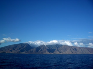
The windward coast of the Big Island is very rugged and beautiful, with steep cliffs and characteristically rough waters. Access to these areas is quite limited, and human populations along the coast are sparse. The Main Hawaiian Island Reef Assessment and Monitoring Program (RAMP) expedition got off to a great start, with nice weather and favorable ocean conditions along the windward shore of North Kohala. The five small boats launched on their first day with views of Pololū Valley under blue skies and light winds. Of course, that did not last long; the winds picked up, and after a couple of days rains moved in, and the swell increased. However the diving was still good, albeit a bit murky at a couple of sites.

Waters off North Kohala, on the northeast coast of the island of Hawai’i. NOAA Photo by B. Vargas-Ángel
 

The opportunity to dive in these remote areas is uncommon, so I would like to share with you a little about what we do and what we have seen on our dives from the perspective of the Benthic Rapid Ecological Assessment (REA) Team. Benthos is the life that inhabits the sea floor, effectively attached to it, whether sessile (attached) or mobile (moving) on it, such as corals, mobile invertebrates, and algae. The Benthic REA team has a pair of divers for each of these three categories. Bernardo and Jake are the coral team, recording coral species and colony sizes and diseases. Molly and Max are the mobile invertebrate team, and they count critters and also work with the ARMS (Autonomous Reef Monitoring Structures; which Max is going to tell you more about soon).
Divers conducting belt transect surveys on the North Kohala Coast of Big Island. NOAA Photo D. White

Rodney is the limu (algae) expert, and he and I are the Line-Point-Intercept (LPI) team; whereby the organism (usually algae or coral) falling underneath the transect line is recorded to species level at every 20cm interval for 25 meters on each of two transect tapes. Photoquads (photographic images of the benthos) are also collected along the transect line. These methods combined gives a good ‘snapshot’ of the benthic community composition at this place and time. Everything out there has a role to play in this complex ecosystem, and looking at community composition can give you the pulse of an area. Our teams return to monitor the same locations year after year, and so will record changes over time.
Species of hard coral, encrusting sponges, and other sessile invertebrates populate the shallow benthos along the east coast of the Island of Hawaii. NOAA Photo D. White


Each of our sites is in depths of 45’ – 60’, too deep for pounding waves, but these areas observe plenty of water motion from surge and currents in these windward waters. Many of the sites that we surveyed were boulder habitats, where fields of boulders were encrusted with all kinds of life: hard corals, rubber corals, algae, sponges, urchins, and a variety of other critters about. It’s a veritable wall of mouths of a variety of shapes, sizes, and colors. The closer you look, the more you see…in fact, it is truly amazing just how much life is out there!


Close-up of sponge. NOAA Photo. D. White
 

When you are on the benthic team, you tend to have your head down most of the time and really don’t see many fish, apart from saddle back wrasses (Thalassoma duperrey) and the Hawaiian toby (Canthagaster jactator), and a few eels hiding out in the cracks. Loving fish like I do, I have made it a point to look around when I’m finished collecting data to see what I might find, and other times a buddy will point something out that I’m missing. I have a number of favorite fish, and so far I have not been disappointed. On the first day a couple of large kahala (Seriola dumerili) swam close to me as just happened to finish my data collection. The next day two reticulated butterflyfish (Chaetodon reticulatus) swam straight up to my mask as I fumbled for my camera. You know that you are in a remote area when the fish come to check you out instead of swimming away! Okay, the flame angel (Centropyge loricula) was a little shy…but that’s typical. At one site a manta ray (Manta birostris) glided around and around a swirling column of ‘opelu (Decapterus macarellus) 30’ high, which could only be topped by the two longnose hawk fish (Oxycirrhites typus) perched in the branches of a black coral. And, I think we’ve seen spinner dolphins every day thus far.

Longnose hawk fish (Oxycirrhites typus) perched on the branches of a black coral. NOAA Photo N. Pomeroy

We have spent the last couple of days on the leeward side of the Big Island and wow! The coral reef communities over here are truly amazing; I really wish my camera could do it justice. I’ll try to get some better pictures for you at South Point tomorrow!